Tile
Brief
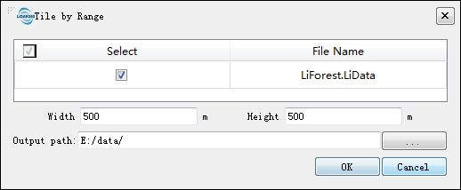
Tile by Range divides the point cloud into a series of small data files based on the user-defined width and length of the small data file. This process begins from the lower-left corner of the input file's bounding box.
Usage
Click Data Management > Point Cloud Tools > Tile
Settings
- Input Data: The input file can be a single point cloud data file or multiple data files. File Format: *.LiData.
- Width (default value is "500"): The width of the data block size, which is the length in the X-axis direction.
- Height (default value is "500"): The length of the data block size, which is the length in the Y-axis direction.
- Output path: Path of the output folder. After the algorithm being executed, new files will be generated.