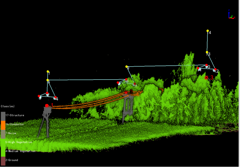
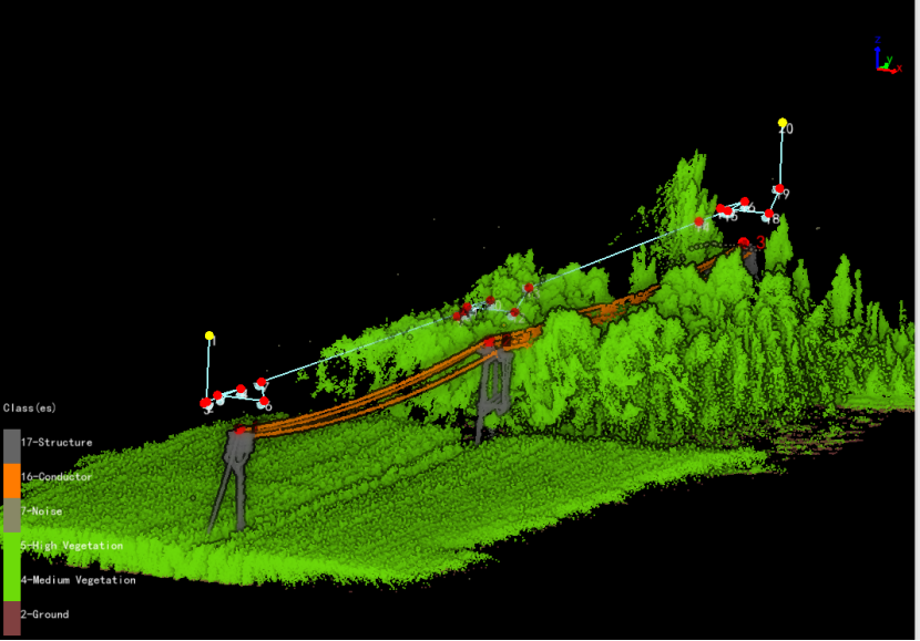
Subscribe

UAV Powerline Inspection: GVI Automated Solution for Effortless Flights and Autonomous Surveying

-- 27 May 2024 --

Background

In recent years, thanks to its advantages such as efficiency and safety, drone inspections have achieved rapid development in the power transmission network inspection business. However, in power distribution networks where the total line length exceeds 10 times, the environment is more complex, and the lines are more variable, traditional drone inspection solutions still face many challenges.


When inspecting distribution lines, if the traditional human inspection solution is adopted, a large amount of human resources will be invested. In some mountainous distribution network inspections, inspection personnel will also face the risks of weather and complex terrain, and are subject to fatigue and location constraints. Inspection results may also contain errors.


If the traditional aircraft patrol solution is adopted, the complex distribution network environment requires high technical requirements for pilots. With route-based operations, manual flight modeling of channels is necessary, and operations rely on RTK signals. Moreover, traditional aerial inspection methods offer limited solutions for identifying and addressing potential hazards such as tree obstacles, which are of significant concern during inspections.


To solve the problem of deep environment perception under complex scissors crossing, buildings, and trees in the distribution network, enhance intelligent intelligent operation and maintenance capabilities, and reduce the pressure on front-line operation and maintenance, we have collaborated with the local power grid unit to launch a LiDAR Automatic Inspection System and Distribution Network Inspection Management Platform. This initiative has significantly improved the efficiency of distribution network operations.


Autonomous Wire-Following Flight: Saving 50% Time


The LiAir X3 Autonomous Power Line Inspection System from GreenValley International enables autonomous wire-following flight and photography along power lines for real-time sensing. Compatible with DJI M300 or M350 drones, it effectively identifies and marks dangerous points like tree obstructions along the wires. After completion, the system can generate a point cloud model of the channel and a report on identified dangerous points. Notably, no RTK signal is necessary throughout the entire autonomous flight. 
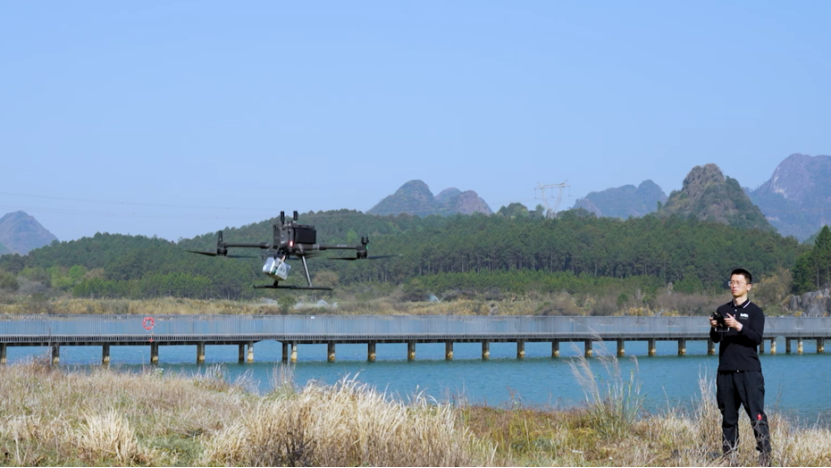

image.png


With the generated point cloud model, high-precision channel modeling can be achieved in the later stage, constructing realistic 3D scene building and digital twin bases, serving as the foundational data for route planning, 3D visualization, inspection result positioning, and LiDAR data analysis.


Local power grid staff conducted comparative tests. Based on the autonomous wire-following operation of GreenValley's LiAir X3, the efficiency of data collection was 50% higher compared to non-Autonomous wire-following operation. Moreover, compared to traditional fieldwork, time was saved by 83%.


Traditional OperationNon-Autonomous Wire-Following OperationAutonomous Wire-Following Operation
100 minutes/kilometer18 minutes/kilometer9 minutes/kilometer


Main functions of GreenValley's LiPowerline software


Clipping Tower

Individual display of specific tower point clouds, with adjustable horizontal and vertical buffer zones, and adjustable scene rotation.
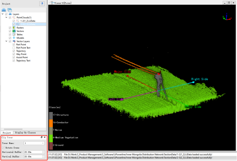


image.png


Generate Distribution Routes


Supports two modes: 3 photos (overhead, left, and right views of the tower head) and 6 photos (overall view, minor side, major side, overhead, left, and right views of the tower head). Camera types supported include mainstream DJI drones.


Software page
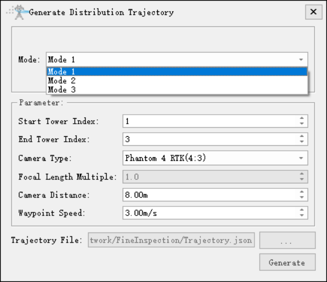

image.png


3 Photo Mode Routes


image.png


6 Photo Mode Routes


image.png


Generate Channel Route

After setting the route parameters, the channel inspection route can be automatically generated.
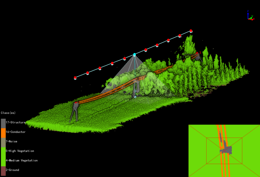

image.png


Interactive Route Generation


Click on the target point on the tower to automatically generate a waypoint, and use the 3D view direction as the waypoint camera direction.
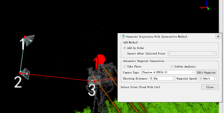


image.png


Merge/Split Routes


Routes can be merged and split to meet different operating scenarios.
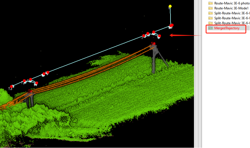

image.png


image.png


Safety Check


Automatically calculate the closest distance between the route and the point cloud. Routes that do not meet the distance will be marked in red.


image.png


Waypoint Editing


Adjust the angle, distance and other parameters of the waypoint.


image.png


Four Key Achievements of Implementation: Empowering the Construction of a Digital Operation System


Over a year of implementation has demonstrated that the LiDAR Automatic Inspection System and Power Line Inspection Management Platform have brought four significant achievements to power line inspection operations, assisting in the digitalization and visualization of regional drone operations.


Firstly, the system applies AI technology in the field of power line inspection, enhancing efficiency and safety. It enables simultaneous drone autonomous wire-following flight and data acquisition, automatic target recognition, and collection of LiDAR point clouds and visible light images. 


Secondly, it generates a precise inspection route for special channel environments with a single click, quickly and accurately extracting hidden danger target information in power channels through processing and analysis of massive point cloud data. 


Additionally, the system serves as an intelligent inspection terminal, featuring on-site real-time generation of channel point cloud models, real-time viewing, automatic danger point analysis, and simplified defect processing procedures, completing inspection and rectification in one go.


Lastly, it establishes a comprehensive power line drone inspection management system tailored to autonomous drone flight characteristics, unifying drone inspection technology standards and regulating inspection management processes.

Contact us to get a Free Software Trial Code: info@greenvalleyintl.com


Background

In recent years, thanks to its advantages such as efficiency and safety, drone inspections have achieved rapid development in the power transmission network inspection business. However, in power distribution networks where the total line length exceeds 10 times, the environment is more complex, and the lines are more variable, traditional drone inspection solutions still face many challenges.


When inspecting distribution lines, if the traditional human inspection solution is adopted, a large amount of human resources will be invested. In some mountainous distribution network inspections, inspection personnel will also face the risks of weather and complex terrain, and are subject to fatigue and location constraints. Inspection results may also contain errors.


If the traditional aircraft patrol solution is adopted, the complex distribution network environment requires high technical requirements for pilots. With route-based operations, manual flight modeling of channels is necessary, and operations rely on RTK signals. Moreover, traditional aerial inspection methods offer limited solutions for identifying and addressing potential hazards such as tree obstacles, which are of significant concern during inspections.


To solve the problem of deep environment perception under complex scissors crossing, buildings, and trees in the distribution network, enhance intelligent intelligent operation and maintenance capabilities, and reduce the pressure on front-line operation and maintenance, we have collaborated with the local power grid unit to launch a LiDAR Automatic Inspection System and Distribution Network Inspection Management Platform. This initiative has significantly improved the efficiency of distribution network operations.


Autonomous Wire-Following Flight: Saving 50% Time


The LiAir X3 Autonomous Power Line Inspection System from GreenValley International enables autonomous wire-following flight and photography along power lines for real-time sensing. Compatible with DJI M300 or M350 drones, it effectively identifies and marks dangerous points like tree obstructions along the wires. After completion, the system can generate a point cloud model of the channel and a report on identified dangerous points. Notably, no RTK signal is necessary throughout the entire autonomous flight. 


image.png


With the generated point cloud model, high-precision channel modeling can be achieved in the later stage, constructing realistic 3D scene building and digital twin bases, serving as the foundational data for route planning, 3D visualization, inspection result positioning, and LiDAR data analysis.


Local power grid staff conducted comparative tests. Based on the autonomous wire-following operation of GreenValley's LiAir X3, the efficiency of data collection was 50% higher compared to non-Autonomous wire-following operation. Moreover, compared to traditional fieldwork, time was saved by 83%.


Traditional OperationNon-Autonomous Wire-Following OperationAutonomous Wire-Following Operation
100 minutes/kilometer18 minutes/kilometer9 minutes/kilometer


Main functions of GreenValley's LiPowerline software


Clipping Tower

Individual display of specific tower point clouds, with adjustable horizontal and vertical buffer zones, and adjustable scene rotation.


image.png


Generate Distribution Routes


Supports two modes: 3 photos (overhead, left, and right views of the tower head) and 6 photos (overall view, minor side, major side, overhead, left, and right views of the tower head). Camera types supported include mainstream DJI drones.


Software page


image.png


3 Photo Mode Routes


image.png


6 Photo Mode Routes


image.png


Generate Channel Route

After setting the route parameters, the channel inspection route can be automatically generated.


image.png


Interactive Route Generation


Click on the target point on the tower to automatically generate a waypoint, and use the 3D view direction as the waypoint camera direction.


image.png


Merge/Split Routes


Routes can be merged and split to meet different operating scenarios.
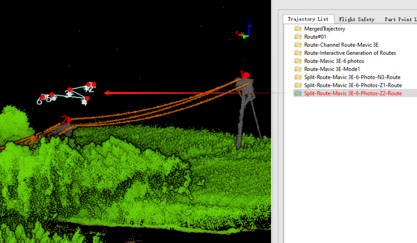

image.png


image.png


Safety Check


Automatically calculate the closest distance between the route and the point cloud. Routes that do not meet the distance will be marked in red.
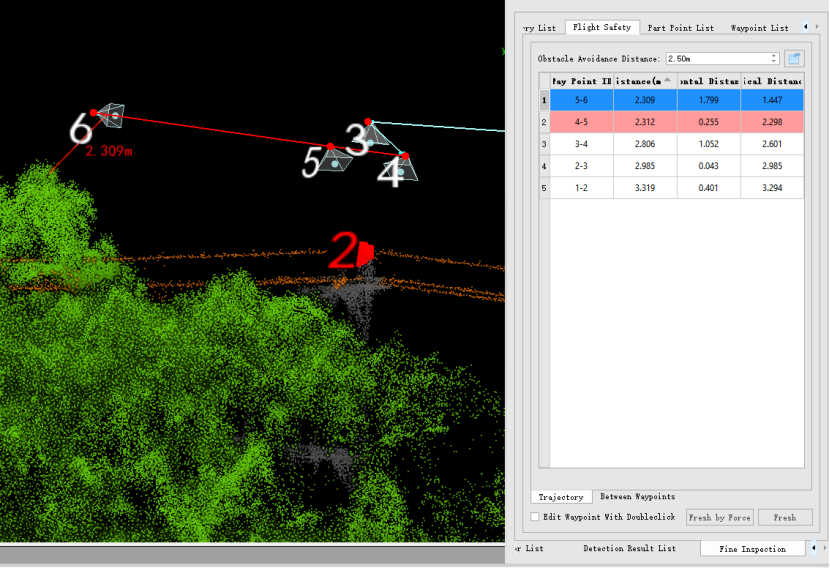

image.png


Waypoint Editing


Adjust the angle, distance and other parameters of the waypoint.
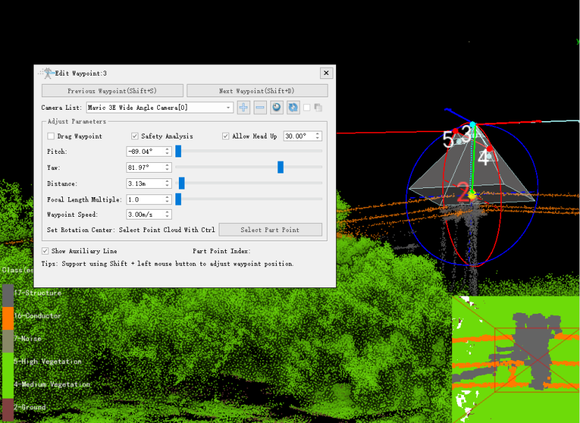

image.png


Four Key Achievements of Implementation: Empowering the Construction of a Digital Operation System


Over a year of implementation has demonstrated that the LiDAR Automatic Inspection System and Power Line Inspection Management Platform have brought four significant achievements to power line inspection operations, assisting in the digitalization and visualization of regional drone operations.


Firstly, the system applies AI technology in the field of power line inspection, enhancing efficiency and safety. It enables simultaneous drone autonomous wire-following flight and data acquisition, automatic target recognition, and collection of LiDAR point clouds and visible light images. 


Secondly, it generates a precise inspection route for special channel environments with a single click, quickly and accurately extracting hidden danger target information in power channels through processing and analysis of massive point cloud data. 


Additionally, the system serves as an intelligent inspection terminal, featuring on-site real-time generation of channel point cloud models, real-time viewing, automatic danger point analysis, and simplified defect processing procedures, completing inspection and rectification in one go.


Lastly, it establishes a comprehensive power line drone inspection management system tailored to autonomous drone flight characteristics, unifying drone inspection technology standards and regulating inspection management processes.

Contact us to get a Free Software Trial Code: info@greenvalleyintl.com


Recommended Articles

HOW CAN WE HELP YOU?
Message us your questions and contact information.
We’ll get back to you right away!