Subscribe

Building digital Hong Kong: GVI and the Hong Kong Productivity Council (HKPC) work together to launch a journey of smart city innovation.

-- 28 Oct 2024 --

1. Project context

With the rapid pace of global urbanisation, traditional urban management methods face increasing challenges. As an international metropolis, Hong Kong’s complex urban management needs and urgent demand for innovative technologies are especially prominent. Therefore, Hong Kong is committed to embracing the smart city concept to enhance operational efficiency, improve the quality of life for its residents, and strengthen its capacity for sustainable development.

In this fast-evolving digital era, GVI is committed to integrating cutting-edge technologies to advance smart city development. Our flagship product, LiMobile M1, supports the Hong Kong Productivity Council (HKPC) in exploring smart city solutions, representing not only technological innovation but also a leap in refined management and digital services for Hong Kong.

The core of a smart city lies in accurate data collection and efficient utilisation. The LiMobile M1, with its excellent 3D modelling capabilities, high-precision image acquisition, and processing performance, delivers professional solutions for 3D map construction, road asset management, 3D scene simulation, and other key areas.


图片1.png


image.png


2. Solution

GVI is collaborating with the Hong Kong Productivity Council to drive smart city innovation. The LiMobile M1, with its exceptional 3D modelling capabilities, high-precision image acquisition and processing, and integration with GVI's proprietary LiDAR360 MLS software, offers a comprehensive solution for smart city development.

This encompasses key areas such as 3D map construction, road asset management, and 3D scenario simulation. These technologies not only drive technological, refined, and digital urban management in Hong Kong but also enhance emergency response optimization and urban planning and design capabilities, strengthening the city's adaptability and resilience.
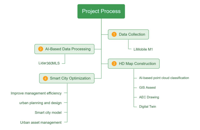

image.png


3.LiMobile M1 mobile laser scanning system


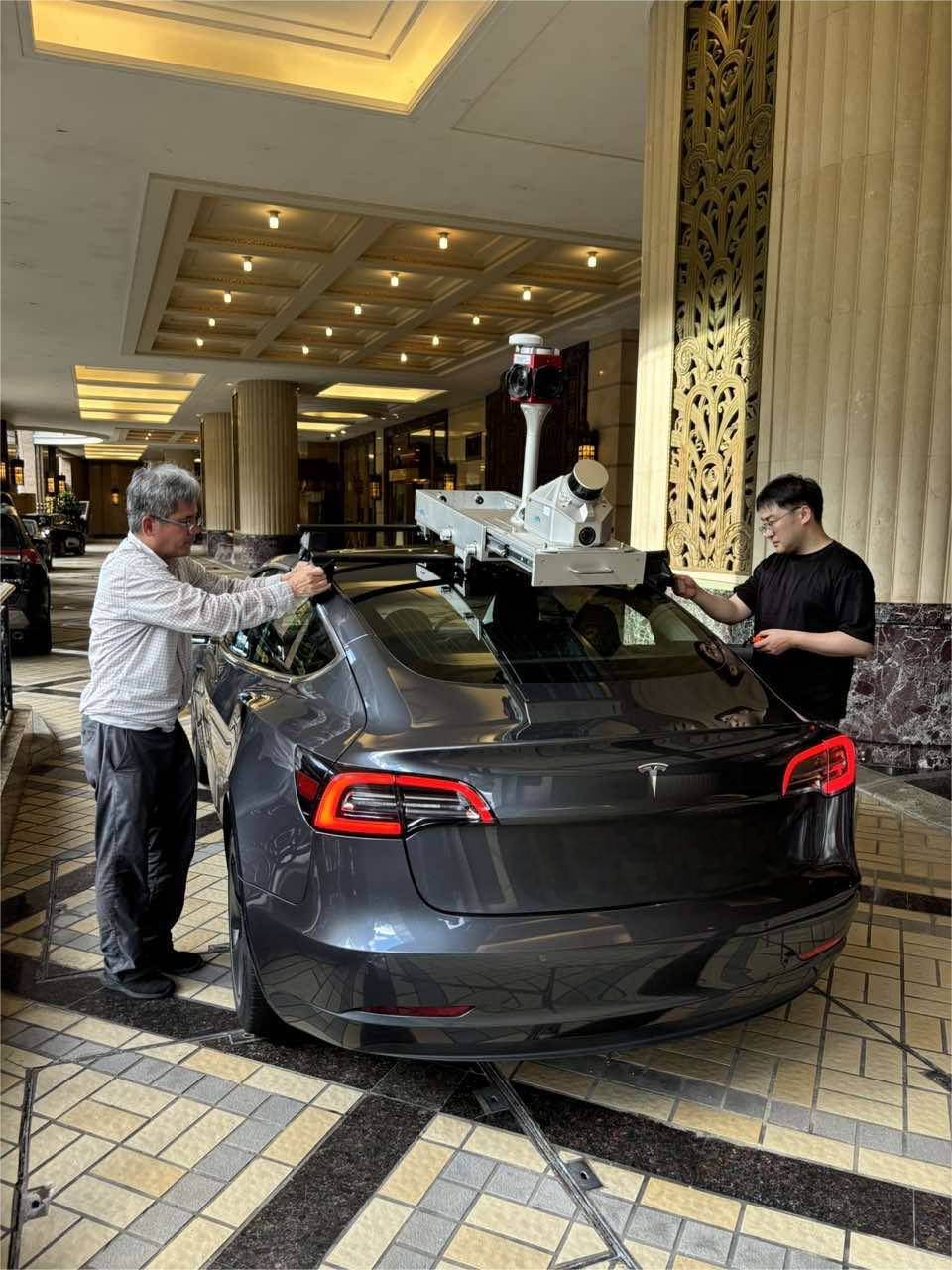
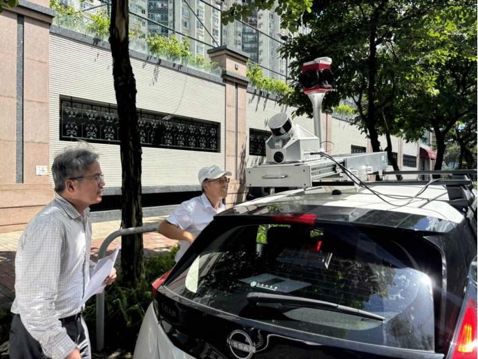
The LiMobile M1 mobile laser scanning system combines a lidar sensor with a 45-degree tilt angle, a high-resolution camera, and a Ladybug5+ panoramic camera, enabling quick 3D data capture of roadways and their surroundings. The system offers versatile expansion options, supports an optional wheel encoder, and includes a 2TB pluggable hard disk for convenient data storage and transfer. Its integrated on-board bracket design allows for easy installation across a variety of vehicles. Paired with LiDAR360 MLS software, independently developed by GVI, LiMobile M1 offers a complete solution, from data processing to professional-grade results.
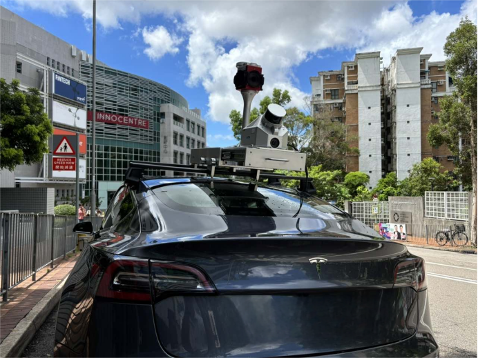


image.png


(1) Lightweight design

LiMobile M1 The lightweight and compact design greatly reduces the internal space occupation of the equipment. The weight of the integrated equipment is only 12.68 kg, ensuring the convenience and speed of installation and transportation.

(2) Real-time monitoring function

The system supports real-time display of the collected data in the Web interface and monitoring the running status of the device.

(3) Ability to work continuously

Through the hot plug-out battery design, LiMobile M1 can ensure a continuous and stable power supply, to ensure the need for long time operation.

(4) Multi-sensor integration

The system integrates various sensors, such as a multi-line laser scanner, GNSS / INS combined navigation system and high-resolution camera, which can provide high-definition point cloud data and image data.

(5) Rich scalability

LiMobile M1 Provide pluggable storage hard disk, DMI, USB 3.0, LAN and other expansion interfaces to meet different expansion requirements.

(6) Applicable to multi-industry applications

The system is widely used in road assets surveys, urban power surveys, urban landscaping, intelligent transportation and other fields, providing accurate data support for different industries.
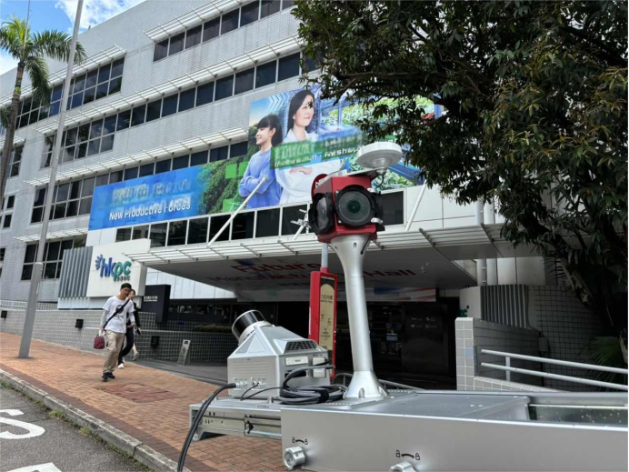
image.png


4. Data collection location:

1) Tuen Mun Yau Oi Road
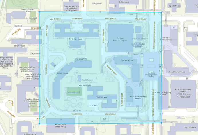


image.png


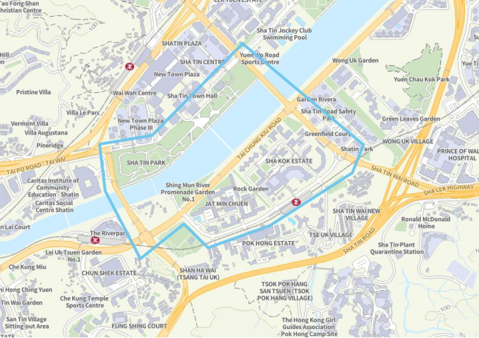
2) Tai Chung Kiu Road


image.png


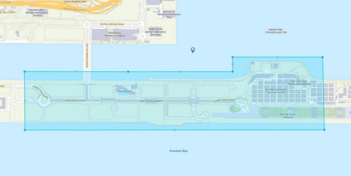
3) Kai Tak Development Area


image.png 

5. Application of the Hong Kong Productivity Council

The Hong Kong Productivity Council has applied LiMobile M1 technology in several areas, aiming to promote the development of smart cities in Hong Kong:

(1) High-definition map construction and 3D scene construction

LiMobile M1 HD(high definition) map-building tasks in streets and key areas in Hong Kong to generate high-resolution city maps. These maps show detailed key information about road networks, traffic signs, road conditions and so on, providing important data support for traffic management departments.
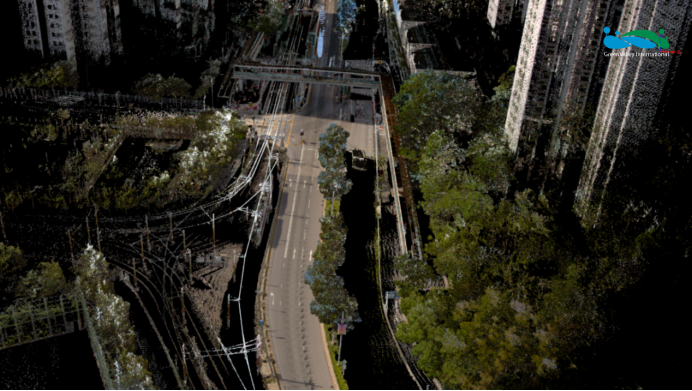
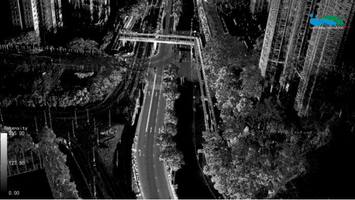
 

image.png


image.png


image.png


LiMobile M1 can build a detailed 3D city model. These three-dimensional scenarios not only provide urban planners with powerful tools for urban planning and design but also can simulate various urban environments and emergencies, thus enhancing the predictability and response-ability of urban management.


image.png


(2) City asset identification and the promotion of smart cities

With AI-based Road Marking and Facility Extraction. Complete AI pipeline for point cloud and image data from annotation, training to inference. LiMobile M1 can accurately identify and locate a variety of assets in urban roads, covering streetlights, traffic lights, road markings, and various road facilities. This function provides the city management department in Hong Kong with intelligent asset management, thus optimizing the efficiency of maintenance operations.


image.png


image.png


Hong Kong has adopted the LiMobile M1 technology and promoted the multi-dimensional progress of smart city construction. By AI-based Point Cloud Intelligent Classification (Built-in pre-trained models for various scenarios).


image.png

image.png


Asset management improvement: through automatic detection technology and data analysis, it can update road assets in real-time, improve the efficiency of maintenance work and extend the service life of assets.


image.png


image.png


Emergency response is optimized: the 3D model can be used to simulate natural disasters and emergencies and formulate emergency plans in advance to enhance the resilience of the city.


image.png


(3) Urban planning and design

3D Visualization Aided Planning: Through 3D modelling, city managers can intuitively simulate future urban development and road expansion plans, assisting in making better-informed planning decisions. For example, when planning new roadways or bridges, 3D modelling can simulate the interaction of these facilities with the existing urban infrastructure, avoiding irrational designs.

Enhancing Urban Adaptability and Resilience: In the face of natural disasters, traffic congestion, and other emergencies, smart city systems can leverage 3D modelling and data from asset surveys to perform simulations and analyses, making rapid response decisions to improve the city’s capability to cope.


image.png


6. Epilogue

GVI's technical solutions align closely with the long-term vision for Hong Kong's smart city development and advance the digitalization, networking, and intelligence of urban management, improving resource efficiency and environmental standards. Combined with Hong Kong's existing infrastructure and resources, GVI’s LiMobile M1 not only modernizes and standardizes urban governance but also provides a significant boost to Hong Kong's residential environment and competitiveness.

Looking ahead, we anticipate the LiMobile M1’s impact in Hong Kong and globally, further advancing smart city development. We are committed to collaborating with leading cities worldwide to build an efficient bridge between the physical and digital worlds, exploring new possibilities for smart cities together. GVI illuminates every corner with innovative technology, envisioning a brighter future for our cities alongside you.

GVI is dedicated to harnessing innovative technology, with the LiMobile M1 being just one of the many solutions guiding us toward a better future.


1. Project context

With the rapid pace of global urbanisation, traditional urban management methods face increasing challenges. As an international metropolis, Hong Kong’s complex urban management needs and urgent demand for innovative technologies are especially prominent. Therefore, Hong Kong is committed to embracing the smart city concept to enhance operational efficiency, improve the quality of life for its residents, and strengthen its capacity for sustainable development.

In this fast-evolving digital era, GVI is committed to integrating cutting-edge technologies to advance smart city development. Our flagship product, LiMobile M1, supports the Hong Kong Productivity Council (HKPC) in exploring smart city solutions, representing not only technological innovation but also a leap in refined management and digital services for Hong Kong.

The core of a smart city lies in accurate data collection and efficient utilisation. The LiMobile M1, with its excellent 3D modelling capabilities, high-precision image acquisition, and processing performance, delivers professional solutions for 3D map construction, road asset management, 3D scene simulation, and other key areas.


图片1.png


image.png


2. Solution

GVI is collaborating with the Hong Kong Productivity Council to drive smart city innovation. The LiMobile M1, with its exceptional 3D modelling capabilities, high-precision image acquisition and processing, and integration with GVI's proprietary LiDAR360 MLS software, offers a comprehensive solution for smart city development.

This encompasses key areas such as 3D map construction, road asset management, and 3D scenario simulation. These technologies not only drive technological, refined, and digital urban management in Hong Kong but also enhance emergency response optimization and urban planning and design capabilities, strengthening the city's adaptability and resilience.


image.png


3.LiMobile M1 mobile laser scanning system


The LiMobile M1 mobile laser scanning system combines a lidar sensor with a 45-degree tilt angle, a high-resolution camera, and a Ladybug5+ panoramic camera, enabling quick 3D data capture of roadways and their surroundings. The system offers versatile expansion options, supports an optional wheel encoder, and includes a 2TB pluggable hard disk for convenient data storage and transfer. Its integrated on-board bracket design allows for easy installation across a variety of vehicles. Paired with LiDAR360 MLS software, independently developed by GVI, LiMobile M1 offers a complete solution, from data processing to professional-grade results.


image.png


(1) Lightweight design

LiMobile M1 The lightweight and compact design greatly reduces the internal space occupation of the equipment. The weight of the integrated equipment is only 12.68 kg, ensuring the convenience and speed of installation and transportation.

(2) Real-time monitoring function

The system supports real-time display of the collected data in the Web interface and monitoring the running status of the device.

(3) Ability to work continuously

Through the hot plug-out battery design, LiMobile M1 can ensure a continuous and stable power supply, to ensure the need for long time operation.

(4) Multi-sensor integration

The system integrates various sensors, such as a multi-line laser scanner, GNSS / INS combined navigation system and high-resolution camera, which can provide high-definition point cloud data and image data.

(5) Rich scalability

LiMobile M1 Provide pluggable storage hard disk, DMI, USB 3.0, LAN and other expansion interfaces to meet different expansion requirements.

(6) Applicable to multi-industry applications

The system is widely used in road assets surveys, urban power surveys, urban landscaping, intelligent transportation and other fields, providing accurate data support for different industries.

image.png


4. Data collection location:

1) Tuen Mun Yau Oi Road


image.png


2) Tai Chung Kiu Road


image.png


3) Kai Tak Development Area


image.png 

5. Application of the Hong Kong Productivity Council

The Hong Kong Productivity Council has applied LiMobile M1 technology in several areas, aiming to promote the development of smart cities in Hong Kong:

(1) High-definition map construction and 3D scene construction

LiMobile M1 HD(high definition) map-building tasks in streets and key areas in Hong Kong to generate high-resolution city maps. These maps show detailed key information about road networks, traffic signs, road conditions and so on, providing important data support for traffic management departments.
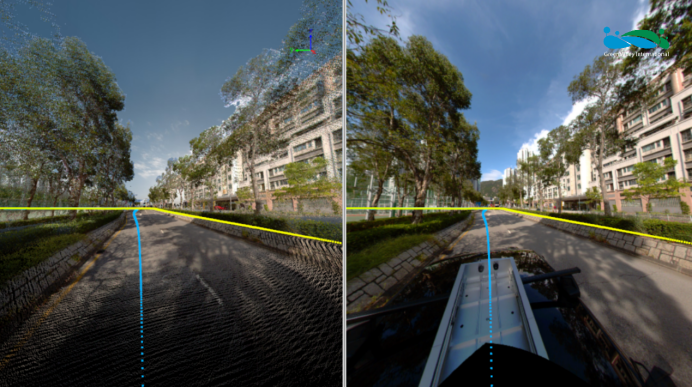
 

image.png


image.png


image.png


LiMobile M1 can build a detailed 3D city model. These three-dimensional scenarios not only provide urban planners with powerful tools for urban planning and design but also can simulate various urban environments and emergencies, thus enhancing the predictability and response-ability of urban management.
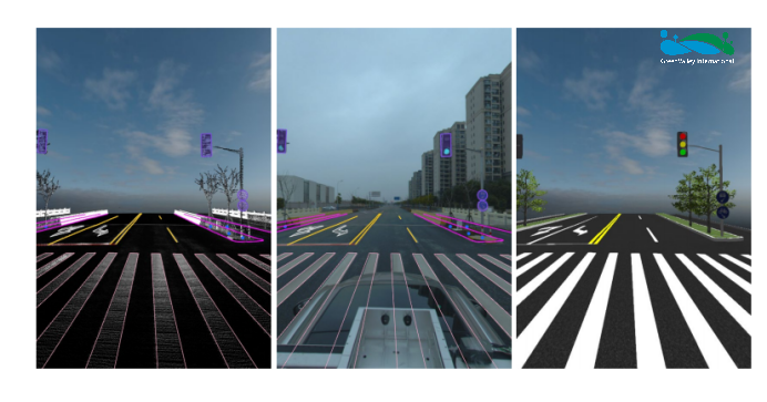
 

image.png


(2) City asset identification and the promotion of smart cities

With AI-based Road Marking and Facility Extraction. Complete AI pipeline for point cloud and image data from annotation, training to inference. LiMobile M1 can accurately identify and locate a variety of assets in urban roads, covering streetlights, traffic lights, road markings, and various road facilities. This function provides the city management department in Hong Kong with intelligent asset management, thus optimizing the efficiency of maintenance operations.
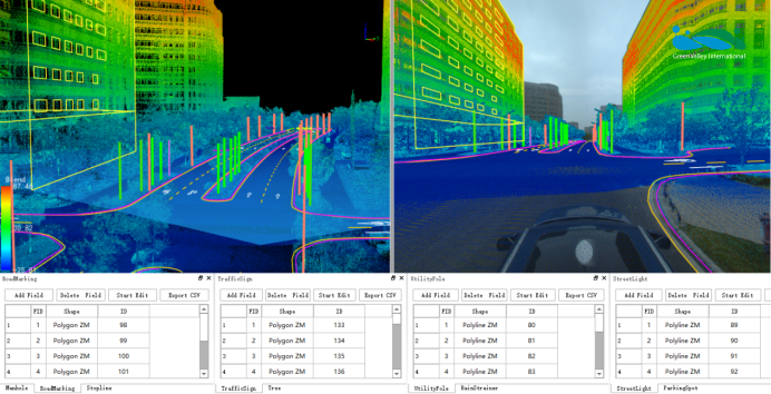
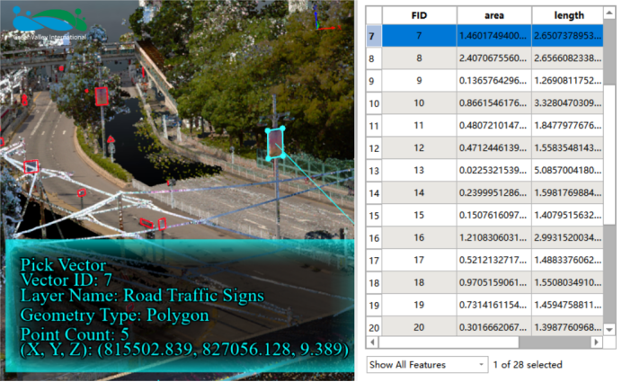
image.png


image.png


Hong Kong has adopted the LiMobile M1 technology and promoted the multi-dimensional progress of smart city construction. By AI-based Point Cloud Intelligent Classification (Built-in pre-trained models for various scenarios).
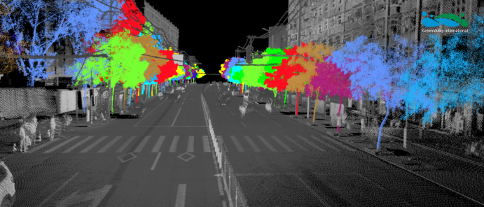
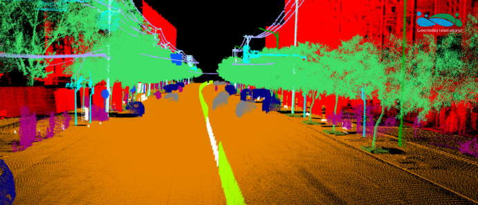
 

image.png

image.png


Asset management improvement: through automatic detection technology and data analysis, it can update road assets in real-time, improve the efficiency of maintenance work and extend the service life of assets.
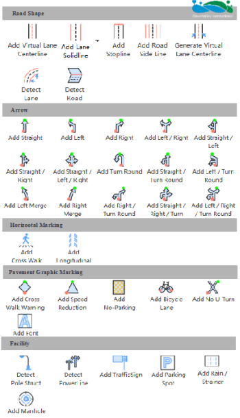
 

image.png


image.png


Emergency response is optimized: the 3D model can be used to simulate natural disasters and emergencies and formulate emergency plans in advance to enhance the resilience of the city.
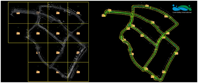


image.png


(3) Urban planning and design

3D Visualization Aided Planning: Through 3D modelling, city managers can intuitively simulate future urban development and road expansion plans, assisting in making better-informed planning decisions. For example, when planning new roadways or bridges, 3D modelling can simulate the interaction of these facilities with the existing urban infrastructure, avoiding irrational designs.

Enhancing Urban Adaptability and Resilience: In the face of natural disasters, traffic congestion, and other emergencies, smart city systems can leverage 3D modelling and data from asset surveys to perform simulations and analyses, making rapid response decisions to improve the city’s capability to cope.


image.png


6. Epilogue

GVI's technical solutions align closely with the long-term vision for Hong Kong's smart city development and advance the digitalization, networking, and intelligence of urban management, improving resource efficiency and environmental standards. Combined with Hong Kong's existing infrastructure and resources, GVI’s LiMobile M1 not only modernizes and standardizes urban governance but also provides a significant boost to Hong Kong's residential environment and competitiveness.

Looking ahead, we anticipate the LiMobile M1’s impact in Hong Kong and globally, further advancing smart city development. We are committed to collaborating with leading cities worldwide to build an efficient bridge between the physical and digital worlds, exploring new possibilities for smart cities together. GVI illuminates every corner with innovative technology, envisioning a brighter future for our cities alongside you.

GVI is dedicated to harnessing innovative technology, with the LiMobile M1 being just one of the many solutions guiding us toward a better future.


Recommended Articles

HOW CAN WE HELP YOU?
Message us your questions and contact information.
We’ll get back to you right away!