Subscribe

High-Precision Mapping Solution for Underground Parking Garages

-- 27 Dec 2023 --

Background


Precise mapping is crucial for indoor positioning, navigation, control, and safety. Generating high-precision maps is also an urgent problem in the field of smart parking. The special conditions of underground spaces, such as poor line of sight and complex structures, make it difficult to collect data using conventional instruments.

Three-dimensional laser scanning technology uses a non-contact measurement method to accurately obtain the spatial geometric information of the object being measured. By dense point cloud data, three-dimensional point cloud data of objects can be quickly obtained, enabling precise positioning within the parking garage. With an indoor map of the parking garage, one can have a clear understanding of the layout of the entire parking facility and the current location of their own vehicle.


High-Precision Mapping Production for Underground Parking Garages


image.png


1. Data collection

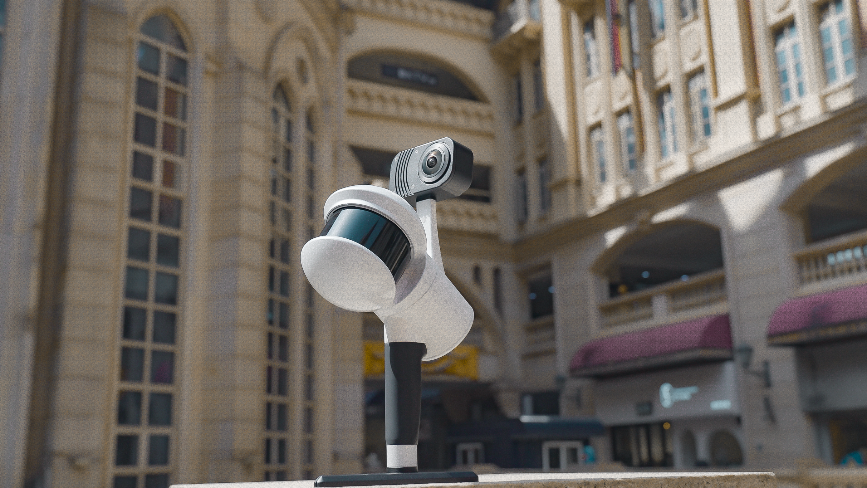
For the data collection of the underground parking garage, the LiGrip H300 handheld SLAM 3D laser scanner developed by Greenvalley International is used. It can be equipped with various sensors to quickly capture data from a large range of scenes. It supports multiple platforms and modes of operation, such as backpack-mounted, vehicle-mounted, and aerial-mounted. It also supports multiple high-precision mapping methods, including PPK-SLAM, RTK-SLAM, and pure SLAM, allowing for rapid acquisition of point cloud data with absolute coordinates. LiGrip is equipped with a panoramic camera capable of measuring distances up to 300m. It employs 32-line point cloud scanning technology, providing better lighting conditions and a scan frequency of up to 640,000 points per second. The measurement accuracy can reach up to 5 centimeters.
H300 (2).png


The measurement personnel use the LiGrip H300 handheld rotating laser scanner to measure the underground parking garage. It is recommended to familiarize themselves with the site environment as much as possible before starting the data collection. If conditions allow, they can conduct a preliminary site survey and plan the collection routes in advance to avoid missing scans or excessive repetitions due to uncertain collection routes.
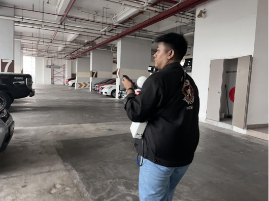
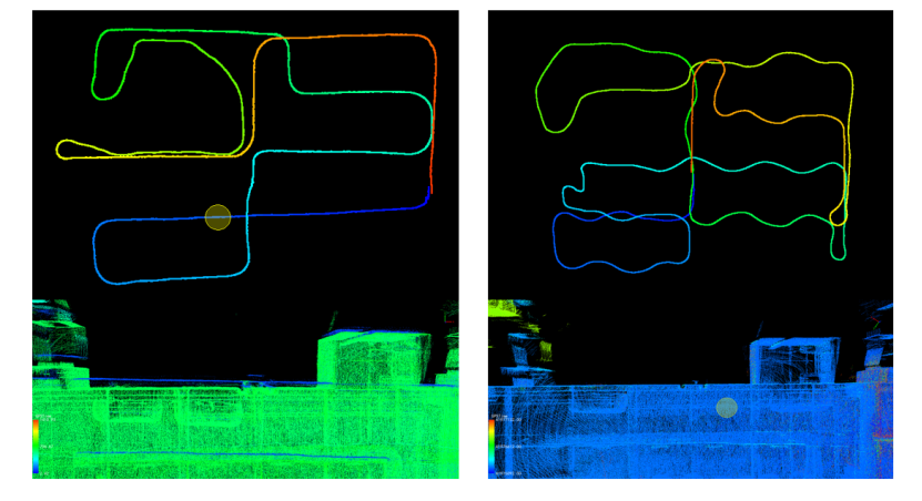
image.png


image.png
 Path Optimization Illustration (Left: Original Path, Right: Optimized Path)


2. Data Processing

After the data collection is completed, the LiFuser-BP software can perform one-click processing of the collected data, allowing for quick acquisition of high-precision
point cloud data.
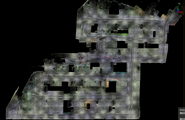


image.png

Point Cloud Data for Underground Parking Garages


3.  
High-Precision Map Production for Underground Parking Garages

The high-precision map production for underground parking garages utilizes the LiDAR360 MLS software developed by Greenvalley International, which enables the intelligent extraction and analysis of 3D features. This software can seamlessly integrate the point cloud and image data collected from various types of mobile measuring devices, such as vehicle-mounted, backpack-mounted, or handheld laser scanners available on the market. The software is based on efficient indexing structures for massive point cloud data and employs artificial intelligence algorithms for point cloud editing, extraction, analysis, and the three-dimensional vectorization of road features.

The LiDAR360 MLS software is characterized by its comprehensive functionality, fast operation, high efficiency, and user-friendly interface. It forms a complete production chain for vehicle-mounted point cloud data processing, high-precision mapping, road component surveys, and maintenance. The output data from the software can be seamlessly integrated with various GIS, CAD, and simulation platforms, making it widely applicable in the fields of high-precision map production, facade measurement, road surveys, and maintenance. LiDAR360MLS leverages intelligent assistance to extract information and digitally depict the world around us. The specific process of map creation is as follows:

(1) Selecting Cross-Sections

Data clipping is performed to display information such as underground parking spaces, zebra crossings, signs, lane markings, and other relevant features. This process involves selectively extracting the desired data from the point cloud to highlight specific elements of interest. By doing so, the underground parking layout and related information can be effectively showcased.
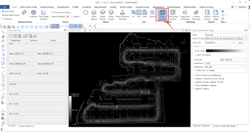

image.png

Select Cross-Sections and Display Intensity


(2) Adding Parking Spaces

Manual generation of parking space vectors, divided into two modes: with shared edges and without shared edges.
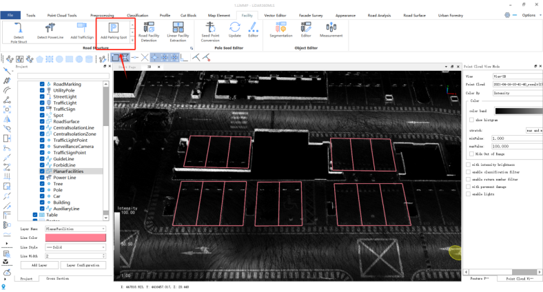

image.png
Add Parking Spaces Function


(3) Drawing Zebra Crossings

To determine the length and width of a pedestrian crosswalk, you can use the three-point method. This involves selecting three points along the crosswalk, such as the two ends and the midpoint, to establish its dimensions. By measuring the distance between these points, you can accurately determine the length and width of the pedestrian crosswalk.
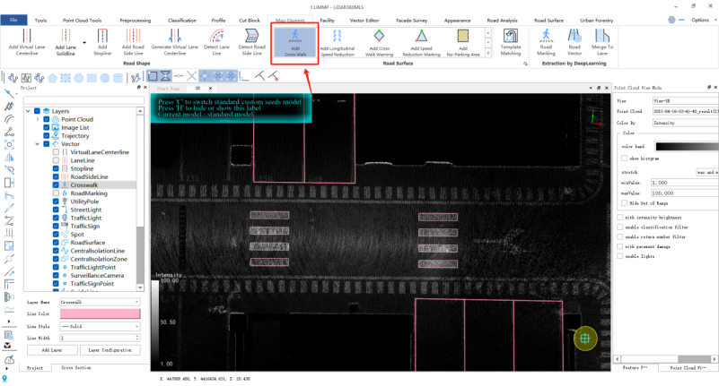
image.png
Zebra Crossing Drawing Function


(4) Drawing Arrow Markings

By clicking on the start and end points of an arrow, you can determine the position and direction of road surface markings. This allows you to accurately place and orientate road surface markings, such as lane arrows or directional indicators, within the software or mapping tool.
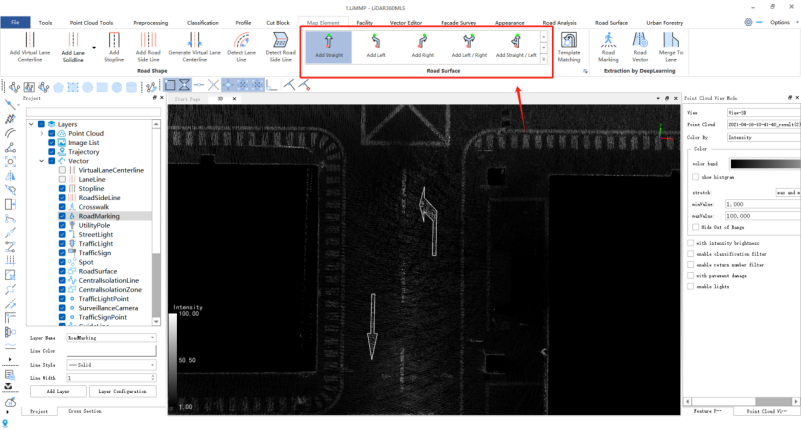
image.png
Drawing arrow marking function


(5) Drawing Lane Markings

After clicking the lane marking button, you can use the left mouse button to select the starting point of the line within the point cloud. By moving the mouse and clicking again, you can add additional nodes to define the shape of the lane marking. To finalize the lane marking, you can quickly double-click the left mouse button. This process allows you to efficiently draw a lane marking by selecting points in the point cloud.
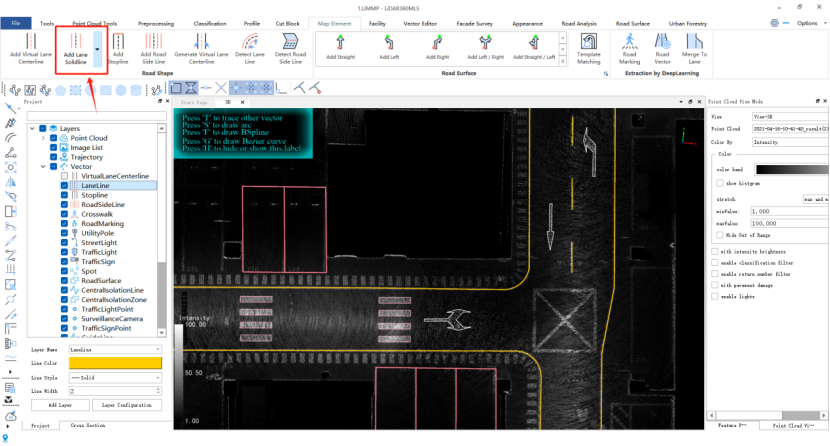
image.png
Drawing Lane Lines Function

(6) Generating Lane Centerlines

By clicking the lane centerline button in the road shape panel, you can use the left mouse button to select the starting point of the line within the point cloud. With subsequent left mouse clicks, you can add additional nodes along the desired path until reaching the endpoint. To finalize the lane centerline, you can quickly double-click the left mouse button. This process allows you to efficiently draw a lane centerline by selecting points in the point cloud.
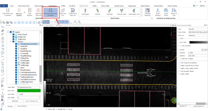
image.png

Automatic lane centerline generation function


(7) Drawing No Temporary Parking Signs
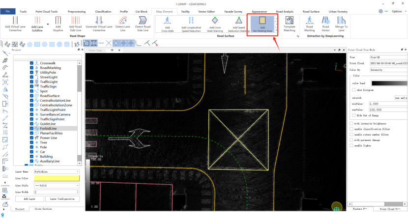

image.png

Drawing of No Temporary Parking Sign Function

(8) Drawing Other Features

For drawing other features, such as ramps, staircases, elevators, entrances, exits, or any other relevant elements, you can follow the same steps mentioned earlier for drawing the previous features. Additionally, you can edit the attributes, colors, and widths of the lines for each layer in the "Vector Editing" menu.
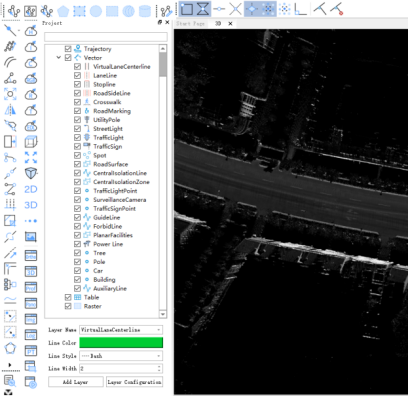
image.png

Vector attribute editing function


By clicking the attribute table configuration button, a pop-up window will appear displaying the specific settings for configuring the attribute table. This interface allows you to customize and define the desired properties and attributes of the table, such as column names, data types, and other relevant settings.
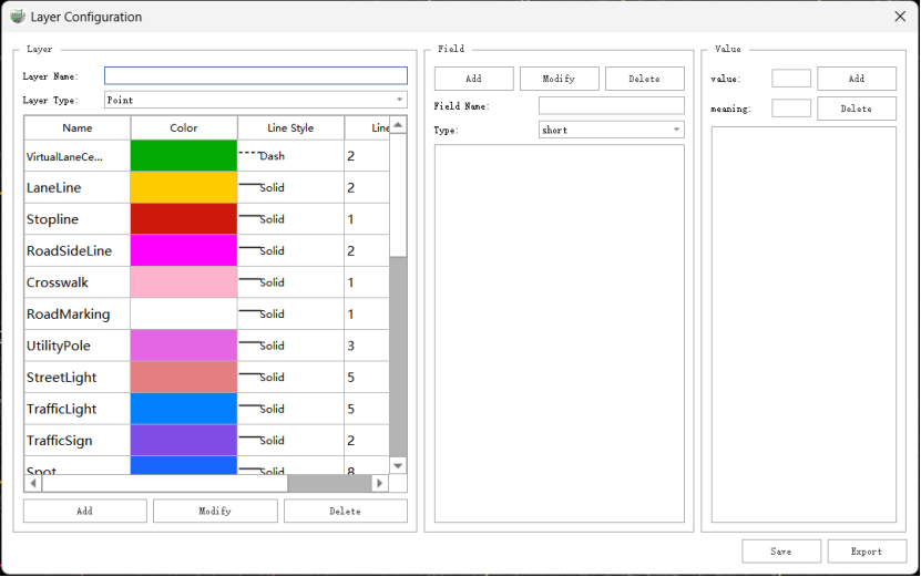

image.png

Property Table Configuration Interface


4. Exporting Results
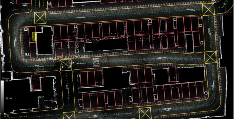

image.png

High-precision underground parking garage map created using LiDAR360MLS


Conclusion

The high-precision underground parking garage map created using LiDAR360MLS encompasses various elements such as parking lot layout, road network, signage, parking spaces, and facilities. This comprehensive map addresses the parking needs of drivers, helping them find available parking spaces in real time and eliminating challenges like difficulty finding parking spots or locating parked vehicles. Moreover, it aids parking management authorities in enhancing vehicle management and operational efficiency.


Recommended Articles

HOW CAN WE HELP YOU?
Message us your questions and contact information.
We’ll get back to you right away!