Subscribe

Latvian Forest Scanning Application

-- 24 Mar 2023 --

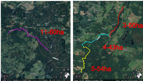
The Latvian Forest Scanning Application is a project aimed at extracting and classifying every tree with a diameter greater than 15 centimeters along the border between Latvia and Belarus. The project uses the LiBackpack DGC50, which integrates a horizontal and vertical dual laser sensors, a GNSS antenna module, and a panoramic color camera to scan the forest area and obtain point cloud data. The obtained data is then processed using LiFuser-BP and LiDAR360 software to extract seed points, calculate tree parameters, and classify tree species. The article provides details about the project planning, data collection, and processing, and shows the high accuracy of the results.
666.png


1.Project Planning and Data Collection

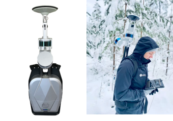
In this project, the LiBackpack DGC50 is used to scan the forest area and obtain point cloud data. The LiBackpack DGC50 integrates a horizontal and vertical dual laser seneors, a GNSS antenna module, and a panoramic color camera. 

图片2.png


The obtained and produced point clouds have absolute geographic coordinates and RGB true color information. The LiBackpack DGC50 uses SLAM algorithm to obtain geographic environmental information and reconstructs 3D point cloud scenes. The algorithm performance depend on the geographic environmental features. Before collecting point clouds, the scanning environment is pre-explored and the measurement path is planned in advance. Due to the large area of the measurement area, the measurement area needs to be divided. In addition, during the measurement process, surveying tools such as total stations are used to collect several reference points with absolute geographic coordinates, which are used for the correction and stitching of point cloud data results.


2.Data Processing and Point Cloud Results


After the collection operation, the LiFuser-BP is used to process the original point cloud data, and the forestry parameters are analyzed using the point cloud post-processing software LiDAR360. LiFuser-BP is used to obtain the result of point clouds (*.Lidata format), and LiDAR360 has professional forestry data processing modules, which can extract seed points, calculate tree parameters, and classify tree species. 

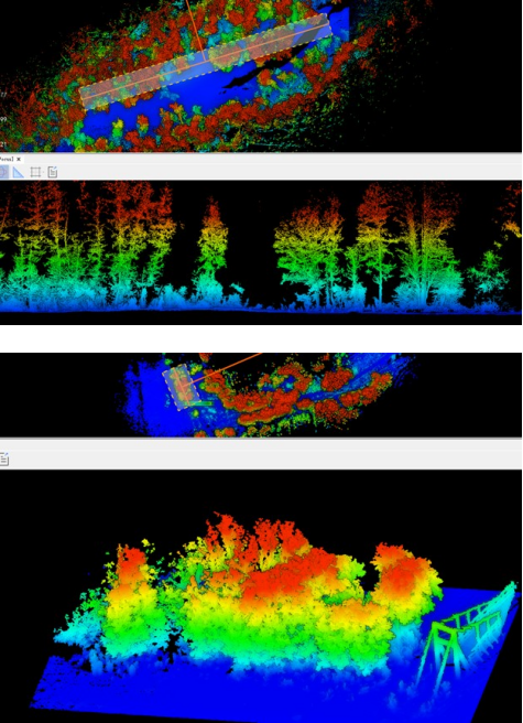
As shown in the figure below, the point clouds are displayed in height mode, and we used the section tool to view the scanning situation of the forest, which can preliminarily judge the completeness and accuracy of the data collection. Users can customize the inspection area and buffer area of the section tool. 

图片3.png


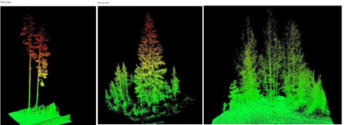
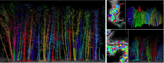
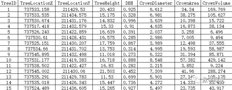
As shown in the figure below, we use the processing tools of the forestry module to obtain the seed points of the trees and segment each individual tree. Calculate the parameters of each tree, including X, Y, Z geographic coordinates, diameter at breast height, crown diameter, crown area, tree height, CBH, and curvature. 

Users can also edit the tree attribute table, add new fields, and classify tree species. 

图片4.png

图片5.png


Finally, the data results delivered to customers through the forestry module in LiDAR360 software are shown in the figure below:

图片6.png

图片7.png


The project results were validated using ground control points, showing high accuracy and meeting project requirements.


The Latvian Forest Scanning Application is a project aimed at extracting and classifying every tree with a diameter greater than 15 centimeters along the border between Latvia and Belarus. The project uses the LiBackpack DGC50, which integrates a horizontal and vertical dual laser sensors, a GNSS antenna module, and a panoramic color camera to scan the forest area and obtain point cloud data. The obtained data is then processed using LiFuser-BP and LiDAR360 software to extract seed points, calculate tree parameters, and classify tree species. The article provides details about the project planning, data collection, and processing, and shows the high accuracy of the results.

666.png


1.Project Planning and Data Collection

In this project, the LiBackpack DGC50 is used to scan the forest area and obtain point cloud data. The LiBackpack DGC50 integrates a horizontal and vertical dual laser seneors, a GNSS antenna module, and a panoramic color camera. 


图片2.png


The obtained and produced point clouds have absolute geographic coordinates and RGB true color information. The LiBackpack DGC50 uses SLAM algorithm to obtain geographic environmental information and reconstructs 3D point cloud scenes. The algorithm performance depend on the geographic environmental features. Before collecting point clouds, the scanning environment is pre-explored and the measurement path is planned in advance. Due to the large area of the measurement area, the measurement area needs to be divided. In addition, during the measurement process, surveying tools such as total stations are used to collect several reference points with absolute geographic coordinates, which are used for the correction and stitching of point cloud data results.


2.Data Processing and Point Cloud Results


After the collection operation, the LiFuser-BP is used to process the original point cloud data, and the forestry parameters are analyzed using the point cloud post-processing software LiDAR360. LiFuser-BP is used to obtain the result of point clouds (*.Lidata format), and LiDAR360 has professional forestry data processing modules, which can extract seed points, calculate tree parameters, and classify tree species. 

As shown in the figure below, the point clouds are displayed in height mode, and we used the section tool to view the scanning situation of the forest, which can preliminarily judge the completeness and accuracy of the data collection. Users can customize the inspection area and buffer area of the section tool. 


图片3.png


As shown in the figure below, we use the processing tools of the forestry module to obtain the seed points of the trees and segment each individual tree. Calculate the parameters of each tree, including X, Y, Z geographic coordinates, diameter at breast height, crown diameter, crown area, tree height, CBH, and curvature. 

Users can also edit the tree attribute table, add new fields, and classify tree species. 
图片4.png

图片5.png


Finally, the data results delivered to customers through the forestry module in LiDAR360 software are shown in the figure below:
图片6.png

图片7.png


The project results were validated using ground control points, showing high accuracy and meeting project requirements.


Recommended Articles

HOW CAN WE HELP YOU?
Message us your questions and contact information.
We’ll get back to you right away!